


| The World Factbook | ||
|
|
Iles Eparses |
|
|
| Introduction | Iles Eparses |
|
Background:
|
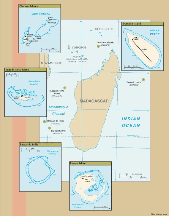
The Iles Eparses, or scattered islands, are a group of five French entities - Bassas da India, Europa Island, Glorioso Islands, Juan de Nova Island, and Tromelin Island - which on 1 April 1960 came under the authority of the Minister in charge of overseas possessions. On 19 September 1960 by decree, the islands were transferred to the charge of the Prefet of Reunion where they remained until 3 January 2005 when they were transferred by another decree to the Senior Administrator of the Territory of the French Southern and Antarctic Lands (TAAF).
Bassas da India: A French possession since 1897, this atoll is a volcanic seamount surrounded by reefs and awash at high tide. Europa Island: A French possession since 1897, the island is heavily wooded; it is the site of a small military garrison that staffs a weather station. Glorioso Islands: A French possession since 1892, the Glorioso Islands are composed of two lushly vegetated coral islands (Ile Glorieuse and Ile du Lys) and three rock islets. A military garrison operates a weather and radio station on Ile Glorieuse. Juan de Nova Island: Named after a famous 15th century Spanish navigator and explorer, the island has been a French possession since 1897. It has been exploited for its guano and phosphate. Presently a small military garrison oversees a meteorological station. Tromelin Island: First explored by the French in 1776, the island came under the jurisdiction of Reunion in 1814. At present, it serves as a sea turtle sanctuary and is the site of an important meteorological station. |
| Geography | Iles Eparses |
|
Location:
|
Southern Africa, in the Indian Ocean
Bassas da India: atoll in the southern Mozambique Channel, about half way from Madagascar to Mozambique Europa Island: island in the Mozambique Channel, about half way between southern Madagascar and southern Mozambique Glorioso Islands: group of islands in the Indian Ocean, northwest of Madagascar Juan de Nova Island: island in the Mozambique Channel, about one-third of the way between Madagascar and Mozambique Tromelin Island: island in the Indian Ocean, east of Madagascar |
|
Geographic coordinates:
|
Bassas da India: 21 30 S, 39 50 E
Europa Island: 22 20 S, 40 22 E Glorioso Islands: 11 30 S, 47 20 E Juan de Nova Island: 17 03 S, 42 45 E Tromelin Island: 15 52 S, 54 25 E |
|
Map references:
|
Africa |
|
Area:
|
Bassas da India: total - 80 sq km; land - 0.2 sq km; water - 79.8 sq km (lagoon)
Europa Island: total - 28 sq km; land - 28 sq km; water - 0 sq km Glorioso Islands: total - 5 sq km; land - 5 sq km; water - 0 sq km Juan de Nova Island: total - 4.4 sq km; land - 4.4 sq km; water - 0 sq km Tromelin Island: total - 1 sq km; land - 1 sq km; water - 0 sq km |
|
Area - comparative:
|
Bassas da India: land area about one-third the size of The Mall in Washington, DC
Europa Island: about one-sixth the size of Washington, DC Glorioso Islands: about eight times the size of The Mall in Washington, DC Juan de Nova Island: about seven times the size of The Mall in Washington, DC Tromelin Island: about 1.7 times the size of The Mall in Washington, DC |
|
Land boundaries:
|
none |
|
Coastline:
|
Bassas da India: 35.2 km
Europa Island: 22.2 km Glorioso Islands: 35.2 km Juan de Nova Island: 24.1 km Tromelin Island: 3.7 km |
|
Maritime claims:
|
territorial sea: 12 nm
exclusive economic zone: 200 nm; note - Juan de Nova Island and Tromelin Island claim a continental shelf of 200-m depth or to the depth of exploitation |
|
Climate:
|
tropical |
|
Terrain:
|
Bassas da India: atoll, awash at high tide; shallow (15 m) lagoon
Europa Island, Glorioso Islands, Juan de Nova Island: low, flat, and sandy Tromelin Island: low, flat, sandy; likely volcanic seamount |
|
Elevation extremes:
|
lowest point: Indian Ocean 0 m
highest point: Bassas da India 2.4 m; Europa Island 24 m; Glorioso Islands 12 m; Juan de Nova Island 10 m; Tromelin Island 7 m (all unnamed locations) |
|
Natural resources:
|
Bassas da India and Europa Island: none
Glorioso Islands and Juan de Nova Island: guano, phosphates; coconuts Tromelin Island: fish |
|
Land use:
|
Bassas da India - 100% rock, coral reef, and sand; Europa Island - 100% mangrove swamp and dry woodlands; Glorioso Islands - 100% lush vegetation and coconut palms; Juan de Nova Island - 90% forest, 10% other; Tromelin Island - 100% grasses and scattered brush |
|
Natural hazards:
|
all islands subject to periodic cyclones
Bassas da India: maritime hazard since it is under water for a period of three hours prior to and following the high tide and surrounded by reefs |
|
Geography - note:
|
Bassas da India: the atoll is a circular reef that sits atop a long-extinct, submerged volcano
Europa Island and Juan de Nova Island: wildlife sanctuary for seabirds and sea turtles Glorioso Islands: the islands and rocks are surrounded by an extensive reef system Tromelin Island: climatologically important location for forecasting cyclones in the western Indian Ocean; wildlife sanctuary (seabirds, tortoises) |
| People | Iles Eparses |
|
Population:
|
Bassas da India: uninhabitable
Europa Island, Glorioso Islands, Juan de Nova Island: a small French military garrison and a few meteorologists on each possession; visited by scientists Tromelin Island: uninhabited, except for visits by scientists |
| Government | Iles Eparses |
|
Country name:
|
conventional long form: none
conventional short form: Bassas da India, Europa Island, Glorioso Islands, Juan de Nova Island, Tromelin Island local long form: none local short form: Bassas da India, Ile Europa, Iles Glorieuses, Ile Juan de Nova, Ile Tromelin |
|
Dependency status:
|
possessions of France; administered from Paris by the Administrateur Superieur of the Territory of the French Southern and Antarctic Lands (TAAF) |
|
Legal system:
|
the laws of France, where applicable, apply |
|
Executive branch:
|
chief of state: President Jacques CHIRAC of France (since 17 May 1995); represented by Senior Administrator Michel CHAMPON |
|
Flag description:
|
the flag of France is used |
| Economy | Iles Eparses |
|
Economy - overview:
|
no economic activity |
| Communications | Iles Eparses |
|
Communications - note:
|
Europa Island, Glorioso Islands, Juan de Nova Island, Tromelin Island: 1 meteorological station on each possession; note - meteorological station on Tromelin Island is important for forecasting cyclones |
| Transportation | Iles Eparses |
|
Airports:
|
4 (2006) |
|
Ports and terminals:
|
none; offshore anchorage only |
|
Transportation - note:
|
aids to navigation - lighthouses: Europa Island 18m; Juan de Nova Island (W side) 37m; Tromelin Island (NW point) 11m |
| Military | Iles Eparses |
|
Military - note:
|
defense is the responsibility of France |
| Transnational Issues | Iles Eparses |
|
Disputes - international:
|
Bassas da India, Europa Island, Glorioso Islands, Juan de Nova Island: claimed by Madagascar
Tromelin Island: claimed by Mauritius |
|
This page was last updated on 15 March, 2007 |